Create a Universal 3D App in a matter of minutes

We just released version 10.2.6 of 'ArcGIS Runtime for .NET SDK', which now supports 3D and KML files on both Windows Store 8.1, Windows Phone 8.1 and WPF. This means you can now quickly build 3D applications that supports all these platforms. We also released the package on NuGet for your convenience.

As a demonstration how quick it is to create a Windows Phone and Windows Store 3D app, here's a little video creating a universal 3D app from scratch in a couple of minutes:

Create Universal Map App In Under 2 Minutes

We just released the second beta drop of the 'ArcGIS Runtime for .NET SDK', which now supports both Windows Store 8.1, Windows Phone 8.1 in addition to WPF. This means you can now build universal apps with a map control that supports all these platforms. We also released the package on NuGet for your convenience.

As a demonstration how quick it is to create a Windows Phone and Windows Store app, here's a little video creating a universal map app from scratch in 80 seconds:


Note: The nuget package currently doesn't support WPF. You will need to download the full setup to get WPF support as well, instead of using the nuget version.

Building A Powerful Platform for Windows Store Mapping apps

When Microsoft announced WinRT at the Build conference in Anaheim, I instantly started researching and prototyping what this new platform could mean for the company I’m working for. The promise of integrating legacy native code with XAML and .NET seemed to finally be the exactly what I’ve been looking for. Also the tight integration between XAML and DirectX, something which is really complex to get working in WPF was intriguing, since we were often hitting the limit of what XAML could do.

We have a huge amount of native code that does a lot of advanced spatial analysis, advanced map rendering, spatial databases, etc. Even better was that most of it is written in a cross-platform way using C++ and was already running on Windows Classic, Linux, iOS, Android and several other platforms.

In hindsight I’m really amazed how quickly this work can go. Granted a lot of time was spent on researching, prototyping, ‘socializing the idea’ etc, but after we had the bases right, we were actually able to move very fast, and in less than 3 months create a whole new SDK geared for the Windows Store (albeit beta).

The things that made this go so fast was:

  1. We had lots of C++ code that was already written to be compiled cross-platform, so most of the development time was spent on exposing this via the WinRT interface and C++/CX.
  2. We chose to build a hybrid SDK based on both C++ and C#. This enabled us to port large amount of our existing C# code from our WPF and Silverlight SDKs. It also allowed us to not be limited by the inheritance limitations that WinRT has by simply creating .NET class libraries rather than WinRT class libraries, which in turn greatly simplifies the API for other developers.

Things that set us back:

  1. Our rendering engine only supported DirectX 9 and OpenGL. Windows Store apps require DirectX 11, which is quite different from v9, so a lot of work had to be done there, because we wanted to do it in a way that wasn’t being hurt by the least common denominator (ie. if DX11 supports a feature that DX9 or OpenGL doesn’t, it shouldn’t hold us back from using it). In the end, our map rendering engine became better because of it for all the platforms.
  2. The documentation on SurfaceImageSource (the glue behind DirectX and XAML) was very limited.
  3. Some time was spent on making sure the native code passes certification, although not too bad.

Several people both within the company, from Microsoft, MVPs etc has been extremely helpful getting us through those setbacks. Thank you! You know who you are (and yes I owe you beer :-)

So enough about that. Instead, I would really encourage you to go download our SDK. It’s actually free! Just go to our developers siteand hit the download button. You’ll be required to register/sign in – don’t worry – as far as I know we don’t spam :-)

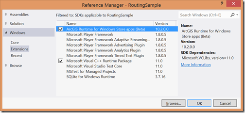
Grab the download, install it, and create a new C# or VB.NET Windows Store app. Add a reference to the ArcGIS Runtime SDKs, set the build target to x86, x64 or ARM (AnyCPU won’t work since this has cool C++ code in its guts).
image

And now code away. There’s a few samples on how to get started with the API as well as a library reference on the developers site.  We know the documentation is a little slim at this point – we’re hard at work improving that. However we do have a getting started tutorial here: http://developers.arcgis.com/en/windows-store/guide/add-a-map-to-your-app.htm

In addition we have a set of samples in the form of a sample browser available today on GitHub: https://github.com/Esri/arcgis-samples-winstore

There’s also a toolkit with some controls here that you are encouraged to fork and contribute to: https://github.com/Esri/arcgis-toolkit-winstore

I did a short introduction to the API at our plenary about 4 mins into this video:

You can download the source code for the sample I built on stage on my github account here: https://github.com/dotMorten/WinStore-Routing-Sample

Go download and code away today, and ask questions and give us feedback in the forum.

Also please go read the official SDK release announcement here: http://blogs.esri.com/esri/arcgis/2013/03/25/arcgis-runtime-sdk-for-windows-store-apps-beta-is-available/

ESRI DevSummit 2011–over'n'out

The ESRI Developer Summit is over, and I had quite a blast. We got tons of great feedback and tough questions from all the developers attending. Thank you for that! We also had some well-attended sessions on Windows Phone, Silverlight and WPF. When these recordings goes live, I’ll update this blog-post.

For the first time, I even got to go on stage during plenary and make a fool of myself. You might already have read about my ventures into programming with a Kinect, but I got to show a far more polished version during the plenary session, and luckily everything worked out great. This version (although not demoed due to time constraints) actually supports multiple users interacting with the map at the same time (at one point we had 4 different people drawing on the map all simultaneously). For those interested, this was based on OpenNI drivers and the ArcGIS API for WPF, which is a different approach than I originally blogged about. Here’s a recording of my 2 minutes of “fame” Smile:

Me on stage making a fool of myself

I have to admit I was a little nervous this would break down during the demo, since this was all based on stuff that wasn’t even in beta software yet. We later had it running at our showcase area 24/7 and I didn’t have to restart the app for almost 3 days running with lots of users playing with it, so perhaps it was running more solid than I had feared Smile - So go play with those OpenNI drivers! They might be called “unstable” but I found them to be very stable.

My little A-to-B app also go a nice mention during the plenary. I wrote this to learn some more phone application practices, exercise the phone API we’ve been working on for a while and simply to have some coding fun. If you have a Windows Phone 7, go download it now, and if not, here’s Dave giving a quick tour of the app.

A-to-B WinPhone7 Application demoed

Thank you to every who attended and especially those who gave us feedback.

Fun times with Kinect and WPF

I recently bought a Kinect controller for my Xbox and is really loving it. Of course I had to see if I couldn’t use that for something, and after some other people were nice enough to create and release free Windows drivers and libraries, I had to try it!

I started out with Code Laboratories “CL NUI Platform” which is a simple installer that installs the drivers and some libraries. It also comes with some samples showing how to connect to the sensor.

I quickly got that going, with a small app that displays the RGB and Depth image from the sensor.

223324934[2]

“Unfortunately” this is also all you get out of the box. If you expect to automatically get an event when you wave your hand or doing some other gesture, this is not for you. However if have a little love for some simple Image Analysis algorithms, you should be all over this too!

I wanted to make a simple gesture API that could tell me when a user drags, pinch/stretch or flicks something, very similar to what you do with a Touch Screen. So basically an API that mimics an invisible touch screen hanging suspended in the air. Luckily the algorithms for this turned out to be pretty simple.

The first thing you do is go through the depth image pixel by pixel. If you find a pixel that is too close or too far away, replace it with Color.Empty so we can ignore those. That we we will only “see” things in the picture that are within a certain distance from the sensor. Like for instance two hands stretched out. This leaves us with a set of pixels that could potential be some stretched out hands.

223411798[2]

We need to associate these pixels with each other. Let’s say all pixels that are next to each other that are not transparent, belong to the same hand. We call these sets of grouped pixels for “Blobs” and there’s a nice simple algorithm for detecting all the blobs in an image, known as “Connected Component Labelling”. Instead of explaining how it works here, all you need to know is here on wikipedia. If you register their center and size, you can easily use these as “touch input” and discard too large or small blobs. This is what this looks like, using a circle for center and size of each blob:

30 times a second you will be calculating a new set of blobs. Compare these to the previous blobs, and use the center and size to see which blobs are the same and has moved, which are new, and which disappeared. If I only have one blob and it moves, I consider this a “drag”. If I have more than 1, I calculate the bounding box of all the blobs, measure its diagonal and compare it to the size of the previous diagonal - The fraction between these two diagonals is the scale in a pinch or stretch.

Now all we need to do is take these “gesture events” and hook them up to something. Like for instance a map. So here’s the end-result: (note : It looks a little jerky because of the screen capture software, but it runs a lot smoother when not recording and flicks works consistently).

Minority MapReport

It worked surprising well for a first go.

Download source: Sorry no source available at this time, due to some licensing restrictions.

Submitted my first WinPhone 7 Application

imageI’ve just submitted my first application to the Windows Phone Marketplace. It’s a very simple app that creates a “Guide Post” with signs on a pole showing distances and direction to any point in the world. You have probably seen these at various sites all over the world, or in the TV Show “M*A*S*H”.

It’s all built in Silverlight, and uses PlaneProjection to give give the signs a 3D effect. You use your finger to slider over the screen to rotate it.

In addition to that there’s a Map where you can view your current location and the great circle line (ie. shortest path) between you and the points of interest. This is of course using the ESRI ArcGIS API for Windows Phone that we just released.

Below is a few screenshots and a video clip of the app in action.

screen_12-1-2010_8.51.30.996screen_12-1-2010_8.50.48.336
screenshot_12-2-2010_12.26.46.864screenshot_12-2-2010_12.27.59.830

GuidePost Screen Capture

It was a great fun little app to build and only took a few evenings to get done. You can download the app to your phone from this link: http://bit.ly/WP7GP

ESRI ArcGIS Silverlight/WPF API released

Last week we finally released v1.0 RTW of our Silverlight/WPF API. Today at our User Conference in San Diego, Jack Dangermond announced, that it even will be free for non-commercial use. The API will run on both v2 and v3 of Silverlight.

Furthermore today we released the entire source code for the toolkit assembly on CodePlex: http://esrisilverlight.codeplex.com

Also today at the Windows Partner Conference, we announced MapIt, a mapping solution running on a combination of SQL Server 2008, IIS and Silverlight/WPF and also with integration into Sharepoint. You can download a free 60-day evaluation of MapIt today. I encourage you to go see some of the demonstration videos – especially if you are new to GIS, this video could be an eye-opener to what information is hidden in your existing business intelligence.

If you are at the ESRI User Conference this week, come by the Silverlight Island in the showcase area and talk some Silverlight. I’ll be there most of the time Tuesday through Thursday. I’ll also be joining Rex Hansen and Art Haddad at the .NET SIG Tuesday evening, and the Silverlight intro sessions Wednesday and Thursday. Also watch Rich’s Demo Theater session which will demonstrate the ESRI Map Web Part for SharePoint and MapIt (the title on this session is incorrect).

ESRI ArcGIS Silverlight/WPF API released

FINALLY we released the beta of our new ArcGIS client API for Silverlight and WPF the end of this week.

You can download the beta here, where you also can find links to documentation and samples. Note that the download requires an ESRI global account, which you can create for free.

Art has the details on his blog.

This his has been (well still is since it's beta :-) a great fun project to work on. We tried to design it to be similar to our JavaScript and Flex APIs, but at the same time make it more ".NET" when it made sense, or taken advantage of capabilities Silverlight had. We really look forward to the feedback from you, as well as talking to anyone who's at the ESRI Developer summit next week. I'll be there Monday through Thursday, mostly hanging out at the showcase area, so if you're there, stop by say hi and get to see the API first hand. Art and Rex will be doing an intro session Wednesday at 1pm, and I'll join them Thursday 10:15am for the advanced session.

Below is a simple flickr application that I created for the api, (source is available for download at the code gallery). Just zoom to any area of interest, hit the flickr button, and images in that area pops up. The sample demonstrates the power of templating the symbols which allows you to associate animations to states of the symbols, as well as using binding. This is really no different than the states model used in other Silverlight controls. The flickr symbols here has two states: MouseOver, which zooms the image and displays a small description at the bottom. The result box to the left uses the selection state when you hover on the features to first scale the image slightly and highlight the border, and if you stay hovering on it, will expand to full size. Click the result to center on that feature.

ArcGIS Server .NET Code Gallery samples

Well what do you know... I'm also on youtube now. Together with several of our team members I'm demoing a custom renderer from the Code Gallery. Check it out!

Here are the links to the samples:

Other samples that you should check out (because I wrote them :-)):

Utility library: Simplifies ADF development for a number of common tasks. For example add a resource in one line of code, or create a redline tool using only a couple lines of code.

DHTML ScaleBar: Pure client-side scalebar. Instead of using the map services for drawing the scalebar, it uses a pure clientside approach (javascript), removing the need for server requests and scalebar re-rendering. It's also useful for resources that doesn't support rendering scalebars.

If you want know more I'll be working at the Server Showcase at the ESRI User Conference next week as well as demoing some more samples at the .NET SIG.